Explore
Featured
Recent
Articles
Topics
Login
Upload
Featured
Recent
Articles
Topics
Login
Upload
Search Results for 'modeling lidar'
modeling lidar published presentations and documents on DocSlides.
Community-wide urban stormwater planning utilizing LiDAR, the WinSLAMM model and GIS
by cheryl-pisano
Dan Murphy. Rebecca Gronewold. UNI GeoTREE Center...
Geospatial Analytics and
by mitsue-stanley
M. odeling Laboratory. Helena Mitasova . http://s...
Geospatial Analysis and Modeling - NCSU MEAS – Helena Mitasova
by ivy
Geomorphometry I: . Terrain modeling. Geospatial A...
3D Archaeological Survey Modeling as a Compliment to Traditional Excavation Methods for Enhanced Vi
by ellena-manuel
By. Paul Roddy. Pennsylvania State University. GE...
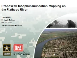
Proposed Floodplain Inundation Mapping on the Flathead Rive
by cheryl-pisano
Travis Ball. Hydraulic Engineer. 206-764-3277. Tr...
Load More...